Two Georgian officials detained for transferring lands to Azerbaijan
Two experts were detained for using incorrect maps of the wrong scale when determining the border with Azerbaijan. Investigators suggest that because of their actions, Georgia has lost more than 3500 hectares of territory.
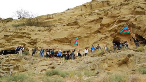
The "Caucasian Knot" has reported that two experts of the Georgian commission on the demarcation and delimitation of the state borders are suspected of having coordinated sections of the border with Azerbaijan to the detriment of the country's interests, the General Prosecutor's Office of Georgia reports. Due to the incomplete demarcation of the border with Azerbaijan, a dispute arose over the "David Garedja" monastery complex, the most important cultural and religious site of Georgia.
In February 2019, Georgian President Salome Zurabishvili announced that the problem on a common section of the state border would be resolved by the end of the year.
During the Soviet era, the Georgian-Azerbaijani border changed several times, and the final decision was made in 1938. In 1996, after the collapse of the USSR, it was agreed that the borders would be determined based on the border on the 1938 map.
The defendants were to find maps and other materials, analyze them, and create an album with maps of the Georgia's borders. However, they "did not ensure the conduct of examinations and did not include cartographers in the process," the Prosecutor's Office reports.
According to the conducted examination, the defendants were guided by the maps issued in 1970-80 and the borders indicated in them.
This article was originally published on the Russian page of 24/7 Internet agency ‘Caucasian Knot’ on October 7, 2020 at 06:43 pm MSK. To access the full text of the article, click here.
Source: CK correspondent


![Tumso Abdurakhmanov. Screenshot from video posted by Abu-Saddam Shishani [LIVE] http://www.youtube.com/watch?v=mIR3s7AB0Uw Tumso Abdurakhmanov. Screenshot from video posted by Abu-Saddam Shishani [LIVE] http://www.youtube.com/watch?v=mIR3s7AB0Uw](/system/uploads/article_image/image/0001/18460/main_image_Tumso.jpg)